
Description of the Geographical „nEtQUIPMENT” (net resource kit)
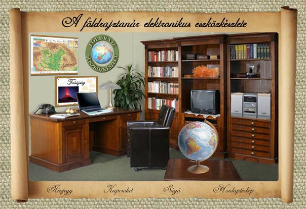
nEtQUIPMENT is a multimedia internet service, and by downloading it for free, after the registration the teacher gets into a virtual workroom (Illustration 1. : Opening scene), and by clicking on various items or on parts of them (drawer, shelf, wall map, globe. laptop, TV…etc.) the teacher can proceed to the neccessary teaching equipment/tool.
Illustration 1.: Opening scene – Virtual workroom In most cases, when done as mentioned above, a so called “paper” page apperars where the teacher would find information about the usage of that specific equipment, and through hyperlinks the teacher can get to other tools. I primarily recommend the homepage to be used by geography teacher and would-be teacher colleagues. The content is based on the regulations of the National Basic Curriculum and the Frame curriculi. I reckon, it contains every such electronic teaching resources that are necessary to prepare for a geography lesson. The complete list of tools are shown in the Sitemap. Recommended resolution: 1024*768, 24 bit color depth. Best monitor size 17'. Softwares used:
Hardware requirements: (under Internet Explorer)
Software requrements:
nEtQUIPMENT contains mainly tools that are used by teachers – principally illustrative and demonstrative tools - ,but through hyperlinks we can get to various knowledegebases (SDT, other English knowledgebases, geographical portals), repertories (picture galleries, electronic libraries,...etc), that enable individual learning and information getting for students as well. Such pages that provide website addresses are the so called “memo” pages. The teacher, who wants to work in the virtual workroom – in case of need –, by clicking on the book on the desk, can look into the description of nEtQUIPMENT. The same option is offered by the About label at th bottom of the homepage.
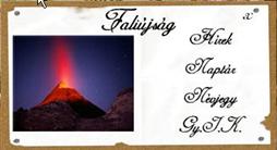
Illustration 2. On the Bulletin board (Illustration 2.) you can see the most current News related to geography. You can get to know e.g. about a volcanian, natural disaster, a political or economical event, or you can learn about various geographical programs that take place in our mother country. Such programs are for example the ones organized by the Hungarian Geographical Society. On the Calendar page, you can get a line on the website’s latest updates. Since nEtQUIPMENT is not definite in its certain parts (it gets new tools, websites are left off, new ones appear...etc), its often updated. The curious ones can also enter the Frequently Asked Questions (FAQ) section on the bulletin board.
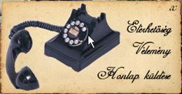
Illustration 3. By clicking on the telephone (Illustration 3.) three further options become available. The Contact label refers to the e-mail addressed to the websites’s creator and maintainer, just like the label located at the bottom of the page. In the Opinions section the users can share their opinion about nEtQUIPMENT, on one hand by answering given question, on the other hand by giving written remarks. Send website enables the website’s address to be sent by e-mail to anyone. The Wall map leads to the world of maps. It guides us to over forty excellent websites, where the geography teacher can find a wide range of come in useful resources: free to download maps, thematic maps, software related to maps (map editor), satellite pictures (of the Earth and the planets of the Solar System). Such one is like the Great Globe Gallery, which contains map collections gathered from various internet sources. The teacher can find interactive maps here, which helps to make teaching and learning the continents, countries, capitals, factors in natural and economical geography easier. You can visit websites containig antique maps (Heritage Antique Map Museum), but you can download the latest NatGeo world map from hte NASA’s homepage. Besides maps there are useable itinerary designer software and timetables are available. When organizing field trips, journeys such software always come in handy.
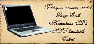
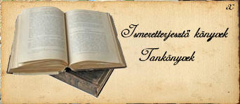
Illustration 4. On the desk – not inadvertently – the central place is occupied by the laptop (illustration 4.) (notebook, mobile computer); according to my expectations by using nEtQUIPMENT it will soon be the primary aid for the geography teacher in his work. The teacher can visit the inland and foreign Geographical internet pages. Here he can get information in different categories: Virtual teaching resources from abroad (>50 links), Knoledgebases inland and abroad (>80 links), Geographical internet portals inland and abroad (>50 links), application of IKT in geography teaching. Highlighted website is Google Earth. Virtual globe with high resolution satellite pictures, with which we can look into the Earth’s “most hidden” corners. It allows detailed search; database and dozens of extra service is at our disposal. In Hungary and abroad – acted upon the curriculum – we can reach the list of Multimedia CDs published after 2000 at the laptop. The following information can be found about the CDs: title, publisher, minimum hardware requirements, informational website, price, audiovisual quality. Here those completed presentations are collected (PPT presentations), that act upon the primary and secondary school curriculum’s material. Also a highlighted link is Sulinet, which leads to its Digital Knowledgebase pages on geography. At present in Hungary, this is the only such digital knowledgebase, that contains resources on geography – among others -, geological databases and interactive blind map collections...etc that meet the requirements of the curriculum. The drawers of the desk hide Lesson plans, digital worksheets, Field trip plans, Geographical games. Among the lesson plans, the ones that describe project work and those that require digital technonogy are highlighted. Nowadays, pedagogues probably have no doubt, that the successful teacher beyond his profound specialized knowledge, must know the efficient usage of modern teaching resources. I reckon, colleagues are more courageous to do so, when they have access to actual lesson plans. One hidden drawer of the desk unveils the list of sources of materials that were used to make nEtSZKÖZTÁR, and the information about copyrights. (I marked this with a ©) Illustration 5. The wardrobe of the virtual workroom reveals more tools (Illustration 5.). The Informing books introduces a wide range of such professional books, which can rise the geography teacher’s attention. He can get information about the book’s title, its publisher, date of publishing, and the price. In the School books section the teacher can be informed about the school books grouped by publisher and age groups in the Hungarian market. Most of the Journals have their own website. The list here guides us to the inland and foreign ones. Such ones are Teaching geography, Geographical informer, Geographer’s newsletter, The globe or the United Kingdom’s Geographical journal. The list also contains the description and catalogue of the non-electonic ones, too. Pedagogues often lack time. There isn’t always time to find, trace the related, fresh literature which would help his work. This is the task of the Professional articles collection, which is a digitalized article collection, that would help the teacher’s methodological work. The Geographical encyclopedia speaks for itself. Digitalized notion collections, lexicons are at service on the various fields of geography. The Libraries enables several dozens of inland and foreign libaraies’ website on geography to be visited. Some of them are: the Hungarian Geographical Society’s Library, Hungarian Electronic Library, The WWW Virtual Library: International Affairs Resources , Awesome Library etc. The Disciplines of Geography tool store groups tools by fields of science. Within General natural geography, General Economical Geography, Geography of Hungary, Regional Geography branches, sub-branches also appear (Astronomy, Plate Tectonics, Volcanism, Geomorphology, Climatology, Paleontology, Tourism geography, Political geography, Cultural geography, GIS...etc) The Mineral and Rock collection lead us to the world of minerals and rocks. The teacher can get – for example – to one of the world’s biggest mineral database (http://www.mindat.org/index.php), in which are able to use a digital mineral identifier. You can roam around in mineral and rock picture galleries (http://kep.tar.hu/mineral), from which you can select the pieces you want to demonstrate in a geography lesson. You can find places, that contain information in both topographic (World map of minerals) and descriptive ways about minerals and rocks, and you can view the Mineral collector’s homepage, too. The camera, which lies on one of the shelves of the wardrobe in the virtual workroom, contains the Pictures. The Pictures tool store on the one hand groups the pictures that act to the curriculum (the author’s photos). On the other hand, it leads to websites where there are loads of (free to download) pictures of landscapes, cities, geographical objects, buildings...etc. Websites like this are for example the Photos and Images of the Earth, Classroom Clipart (Geographical graphic files, illustrations and photographs – more than 30 thousand is downloadable for free). Several hundreds of links like this can be found here. The pictures suggested for use are of size 640*480, color depth 16 bit.
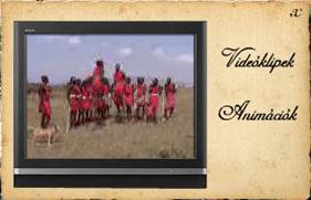
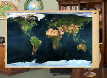
Illustration 6. If we click on the TV, a screen pops up, on which massai warriors tread their war-dances (Illustration 6., with the author’s video recording). With the help of Videoclips we can display such events, that shows far countries, their lives and their natural wonders. The teacher who wants to make his lesson more colourful can select from such videos. Files are in AVI format. It can be played with Windows Media Player (found on every Windows based platform). Several dozens of websites are at the teacher’s disposal to select from videos and Animations. Showing animations make the understanding of complex natural processes easier. It delivers a lot more information than a simple graphical illustration. One, however, must be careful that the clip’s length doesn’t exceed 2 minutes, since it can get boring, and can draw attention from the important parts. By “turning on” the HI-FI equipment – through the Music collection and The “music of the world” on the Internet links – the teacher can browse among pieces of music that are related to geography teaching (e.g.: South-American, African, Asian, European nations’ music...etc) Properties of the digitalized sound files: 22 KHz, 16 bit, stereo. The drawers of the wardrobe contain further useful tools. The Database is one of the most important things for the geography teacher. With the help of more than 30 inland and foreign websites the teacher can find the sought information. A website like this isInteractive World Fact Book (The interactive big book of data of the World, maintained by the CAI), with thousands of virtual information, flags, maps, data on the world’s countries; or theCountry Informations website, which provides statistical and cultural information. In the Illustrations drawer numerous graphics on geography can be found, form which the teacher can selet the most appropriate for him. The Diagrams page grants access to pages, where one can select from ready-made diagrams. These pages are parts of databases; however, by clicking right here, one can save time, instead of looking through databases. The Curriculi and documents that determine geography teaching can also be found in one of the virtual workroom’s drawers. Hopefully, the geography teacher’s favourite place is the Curiosuty storage. More than forty enchanting places, where both teacher and student can dwell on. Some examples of the many:World Safari (Virtual journeys around the world. A visit to Japan, Italy, Kenya or Jamaica. Each safari shows the country from its social, historical, human and geographical aspect.) Geography Humor, Geography Poetry Corner, Geo Mysteries. The CAI’s and NatGeo’s website for children...etc. Under Others one can find all – not to be found anywhere else in nEtQUIPMENT – tools, that the geography teacher might need occasionally. For example: The collection of pedagogical websites, from here can the teacher step to the website of the Ministry of Education; but also you can find enries, like Environmental education on the geography lesson..etc The globe, which is in the middle of the room, embraces the disciplines of the Regional geography. It makes information accessible by the continent (Illustration 7.). We can further roam through the carefully selected, richly informationful website by clicking as we wish on Europe, Asia, Afica, North-, Central-. South-America, Australia and the Arctic.
Illustration 7. The teacher who uses nEtQUIPMENT may think of wanting to systematize his own demonstrative materials, and put them among the other tools. That’s possible, too. By clicking on the armchair (nEtQUIPMENT upload) the geography teacher has two options. The Send tools menu sends the materials to the maintainer of nEtQUIPMENT, which - after being vetted – will be available in it. The other option is My tools, where a directory tree – similar to the site map – is downloadable. This can be save on his own computer, and can put his own tools in it. On every page of nEtQUIPMENT the logo appears at the top, and at the bottom, the About, Contact, Help and Site map appears. When making the website my goal was to bring the content and appearance to a structural unity. Furthermore, I tried to make its communication interface easy to use, and user friendly. The usage of the nEtQUIPMENT do not require any special pre-qualifications, and the teacher soon gets success-experience by using it. I tried to select the colors in a way so that they would be capable of transmitting the profile, raising attention and systematize the tools into unity I have accumulated. Without a demand for completeness, I tried to create an electronic educational tool, that it makes up one whole in its functionality, aesthetic appearance, conception and uniqueness, so it can be a serious aid for the geography teacher in every teaching situation. Ilona Pajtok-Tari |