|
||
Online map page of ELTE’s Cartographical Maps on the Hungarian side of the Web |
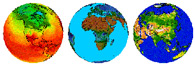
. Colour relief and political maps, information, data, statistics about the world’s countries. |
Map pages of the website of National Geographic Society Satellite pictures, streetmaps, relief and |
National Geographic Xpeditions Free to download; it provides excellent |
|
Map collection of the PC Library of the Napi Maps related to daily political events, |
|
One of the world’s greatest map shop. |
|
|
|
|
The maps of the homepage is printable and copyable for personal and educational purposes |
One of the world’s richest online air image, satellite picture and map collection. |
Maps, globes, thematic and historical maps, |
The website contains loads of world maps,
|
Canadian knowledgebase’s map pages. |
Link collection of map pages |
Magical interactive maps that allow localization |
|
A software pack with which we can create |
Online map drawing tool, which allows |
The publication contains more than 50 printable |
|